
JoH | A comparative study of SWAT model and GRACE satellite for estimating the change of shallow groundwater storage in the well irrigation area of Haihe basin
Hydrological model and Gravity Recovery and Climate Experiment (GRACE) satellites are two relatively independent means of estimating changes in groundwater storage. Due to the influence of satellite orbit design and payload accuracy, the spatial and temporal resolution of GRACE gravity satellites to monitor the mass change of the Earth system is about 200-300 km/month, which greatly limits the application of gravity satellites in groundwater monitoring. To evaluate the credibility of GRACE satellite results, researchers usually compare them with groundwater level monitoring information from wells. However, the observed groundwater level dynamics is an indirect representation of groundwater storage changes and needs to be converted with the help of the lithological parameter of the aquifer water level change zone, "water-feeding degree", which greatly increases the quantitative comparison of gravity satellite results and groundwater level results. uncertainty in the quantitative comparison of gravity satellite results and groundwater level results.
To date, studies comparing gravity satellite and hydrologic model estimates of groundwater storage have tended to be conducted on multi-year trends at the global scale, and few studies have been conducted at regional scales such as sub-basins and water resource divisions on time spans such as monthly, annual, and crop reproductive periods. Partial hydrological models can simulate and output changes in aquifer storage, which provides the possibility of direct comparison with changes in groundwater storage monitored by GRACE satellites. In addition, the hydrological model can provide the spatial distribution of hydrological information at any time step within the simulated time period, which makes up for the limitation of groundwater monitoring wells to spatial and temporal scales, and allows detailed comparison and analysis with GRACE satellite-monitored groundwater storage changes at a finer and more flexible spatial and temporal scale.
This study focuses on the pre-mountain plain of the Taihang Mountains in Hebei Province, which is a typical well irrigation area with continuously declining shallow groundwater levels at the global scale, within the Haihe River Basin where shallow groundwater overdraft is severe (Fig. 1).Zhang et al. (2016) modified the groundwater module of the Soil and Water Assessment Tool (SWAT) model and Using the dynamic monitoring data of shallow groundwater level from 16 national monitoring wells and 148 regional survey wells, we conducted detailed rate determination and validation of relevant parameters. The comparison with the results of groundwater storage variables in the national "new round of groundwater resources evaluation" shows that the improved SWAT achieves acceptable accuracy in the simulation of shallow groundwater storage variation at the regional scale, which is the best solution for "crop growth-soil water dynamics-shallow groundwater storage" in the region so far. This is the first simulation platform that can better realize the joint simulation of "crop growth - soil water dynamics - shallow groundwater change" in this region. In this study, based on the study of Feng et al. (2013), who used the GRACE satellite to estimate the groundwater storage changes in North China, the shallow groundwater storage changes from 2003 to 2012 simulated by Zhang et al. (2016) using the SWAT model as the reference quantity, and further applied the joint inversion method and the forward modeling method. algorithm (see Feng et al., 2017), the results of GRACE satellite data were downscaled to 0.5° raster and transformed to 22 sub-basins (area of about 500-1500 km2 ) of the SWAT model by area-weighted average for comparison.
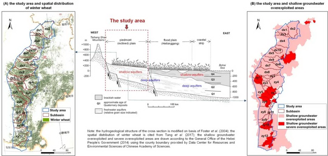
Fig. 1 Geographical location of the study area and spatial distribution of winter wheat (A) and the extent of shallow groundwater overdraft (B).
Under the perspective of water storage variation, the variation of shallow GWS anomalies calculated by GRACE satellite data and SWAT model is more consistent, and the coefficient of determination R2 and Nash coefficient NSE of the two data sets reach about 0.70 and 0.69, respectively, in this region (Figure 2). Meanwhile, the long-term depletion rate of shallow groundwater storage and its spatial distribution obtained by GRACE satellite and SWAT model are also more consistent (Figure 3). This shows, to some extent, the feasibility of applying GRACE satellite data to assess shallow groundwater storage changes at a finer spatial scale in the Taihang Mountains pre-plain of Hebei Province (about 23,000 km2) in the Haihe River basin and its involved. In particular, this study found that GRACE satellite can well capture the agrohydrological characteristics of shallow groundwater storage in the region under the crop rotation pattern of depletion during winter wheat fertility and recovery during summer maize fertility (Figure 4), which provides a good basis for further monitoring and assessment of shallow groundwater storage changes based on GRACE satellite data in the Taihang Mountains Front Plain of Hebei Province, a typical shallow groundwater well irrigation over-extraction area in the Haihe River Basin. This provides an important technical tool for further monitoring and assessment of the changes in groundwater storage based on GRACE satellite data in this typical shallow groundwater well irrigation over-extraction area in the pre-Haihe River Basin of Hebei Province.

Fig. 2 Comparison of the dynamics of shallow groundwater storage and its trend terms in the 22 sub-basins and two water resources tertiary zones involved in the study area and at the scale of the whole study area from 2003 to 2012 under the perspective of water storage changes.
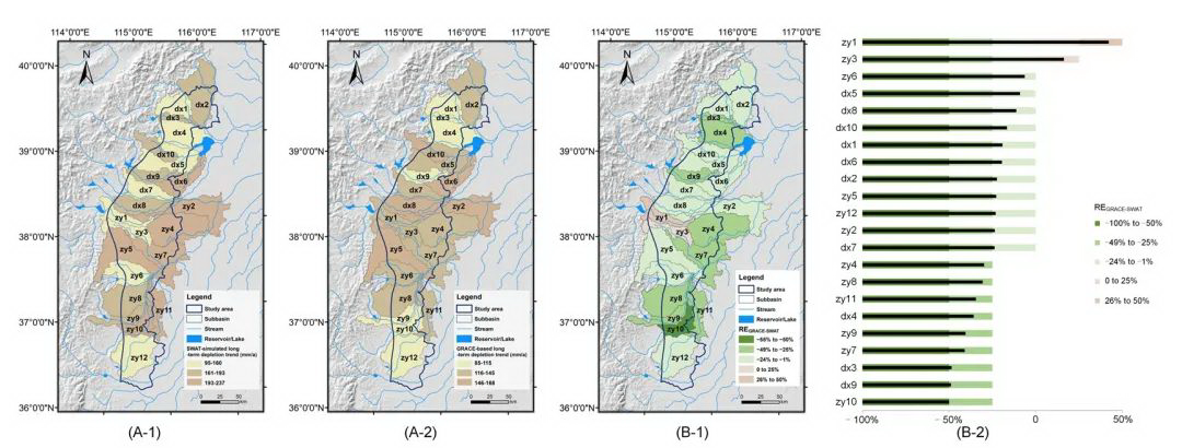
Figure 3 Spatial distribution of SWAT model simulations (A-1) and GRACE satellite-monitored (A-2) shallow groundwater storage depletion rates and their relative errors REGRACE-SWAT (B-1 and B-2) within the 22 sub-basins involved in the study area. Where REGRACE-SWAT is calculated as: REGRACE-SWAT=(RGRACE-RSWAT)/RSWAT, where RGRACE is the depletion rate of shallow groundwater storage from GRACE satellite monitoring (mm/month) and RSWAT is the depletion rate of shallow groundwater storage from SWAT model simulation (mm/ month).
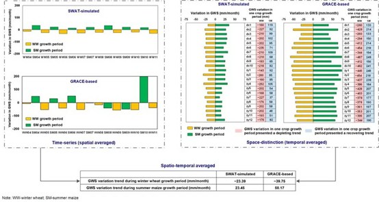
Fig. 4 Comparison of trends in shallow groundwater storage at different spatial and temporal scales between SWAT model simulations and GRACE satellite-monitored changes in winter wheat and summer maize fertility.
This study also found that the water fluxes obtained by the joint inversion algorithm based on GRACE satellite data under the water flux variability perspective are in high agreement with the simulation results of the SWAT model, both in terms of inter-seasonal surplus and deficit characteristics (Figure 5) and inter-annual variability. Despite the large oscillations in the monthly variability of shallow groundwater storage monitored by GRACE satellites, it is exciting that it is able to capture well the trends in shallow groundwater storage depletion due to well irrigation mining in April, May and November (Figure 6), thanks to the advantages of the joint inversion algorithm. Compared with the forward modeling algorithm commonly used in GRACE data processing, the spatial and temporal groundwater variability results obtained based on the joint inversion algorithm at the downscale have significantly improved the ability to capture this signal during the winter wheat reproductive period, especially in spring with high intensity irrigation mining. The above results indicate that the GRACE satellite monitoring results obtained based on the joint inversion algorithm can provide dynamic monitoring of the changes in shallow groundwater storage in the pre-hill plain of Taihang Mountains in Hebei Province, a region where well irrigation of winter wheat and groundwater extraction are highly contradictory in the Haihe River basin.
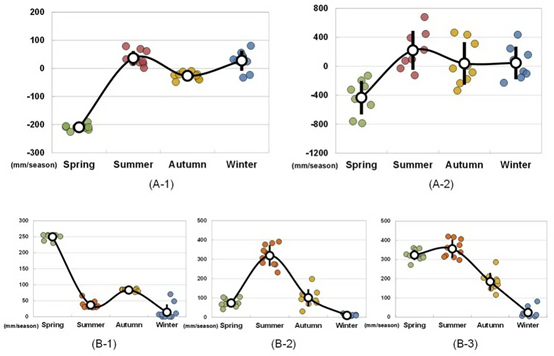
Fig. 5 Seasonal-scale variation of shallow groundwater storage and its sum of irrigation (B-1), precipitation (B-2) and irrigation precipitation (B-3) during the period 2003-2012 from SWAT model simulation (A-1) and GRACE satellite monitoring (A-2) in the perspective of water flux variation.
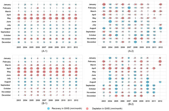
Fig. 6 Monthly changes in shallow groundwater storage between SWAT model simulation (A-1) and GRACE satellite monitoring (A-2) during 2003-2012 and their corresponding results after 3-month sliding average processing under the perspective of water flux change (B-1 is the result of SWAT simulation and B-2 is the result of GRACE monitoring).
The research results were published in the Journal of Hydrology, an international academic journal in the field of hydrology, and were supported by the National Natural Science Foundation of China (41807183, 42061134010 and 41874095).
Citation Format
Zhang, X.L., Ren, L., Feng, W.*, 2022. Comparison of the shallow groundwater storage change estimated by a distributed hydrological model and GRACE satellite gravimetry in a well-irrigated plain of the Haihe River basin, China. Journal of Hydrology, 610, 127799. https://doi.org/10.1016/j.jhydrol.2022.127799
References
Feng, W., Zhong, M., Lemoine, J.M., Biancale, R., Hsu, H.T., Xia, J., 2013. Evaluation of groundwater depletion in North China using the Gravity Recovery and Climate Experiment (GRACE) data and ground-based measurements. Water Resour. Res. 49 (4), 2110–2118. https://doi.org/10.1002/wrcr.20192.
Zhang, X.L., Ren, L., Kong, X.B., 2016. Estimating spatiotemporal variability and sustainability of shallow groundwater in a well-irrigated plain of the Haihe River basin using SWAT model. J. Hydrol. 541, 1221–1240. https://doi.org/10.1016/j.jhydrol.2016.08.030.
Feng, W., Wang, C.Q., Mu, D.P., Zhong, M., Zhong, Y.L., Xu, H.Z., 2017. Ground water storage variations in the North China Plain from GRACE with spatial constraints. Chinese. J. Geophys. 60 (5), 1630–1642. https://doi.org/10.6038/cjg20170502 in Chinese.
