Radar Image Geodesy
1. The theoretical system of statistical inference in the complex domain of InSAR is established as the basis of statistical inference, and the likelihood estimators and confidence intervals for the selection of independent identically distributed samples are derived to ensure the assumption of sample smoothness, which improves the computational efficiency of existing classical methods by nearly 200 times; under the complex circular Gaussian model, the interference coherence, the unbiased estimators of complex covariance matrix and the great likelihood estimators of deformation parameters are derived. Based on the aforementioned theoretical basis, the full-resolution distributed target time-series analysis technique is developed with coherence estimation as the main line, which achieves millimeter-level deformation monitoring accuracy of low coherence surfaces such as vegetation environments under the premise of reliability and improves the overall accuracy of existing mainstream InSAR time-series analysis techniques by 2%-40%.
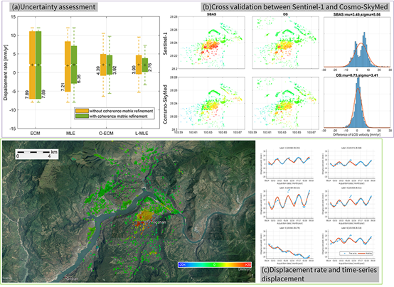
2. DSIpro v2.0 is a synthetic aperture radar interferometry (InSAR) time-series analysis open source software for low coherence surface deformation monitoring such as vegetation environment, which can significantly improve the signal-to-noise ratio of interferometric signals and provide high quality data source for geological researchers. The software is suitable for low coherence surface deformation monitoring in vegetation environment, which can significantly improve the signal-to-noise ratio of interferometric signals and provide high quality data sources for geological researchers. Up to now, the software has been downloaded 1257 times by 104 institutions worldwide, including 34 international institutions such as Purdue University, TUM, UCL, UNAVCO, and 70 domestic institutions such as Peking University, Chinese Academy of Sciences, and WOU. The software can be downloaded at http://mijiang.org.cn/index.php/zh/software-2/.