Precision Gravity Measurement and Scientific Applications
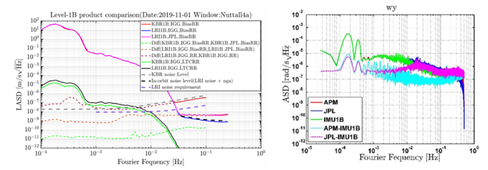
1. Establish the platform of gravity satellite raw data pre-processing system and serve the construction and development of China's independent gravity satellite. Based on this platform, the accuracy of GRACE Follow-On Level-1B product is comparable to the international published product, and the accuracy of laser interference ranging data preprocessing and star-sensitive data preprocessing are better than the international published product. The research results were successfully applied to the inter-satellite ranging data pre-processing of the first gravity satellite in China.
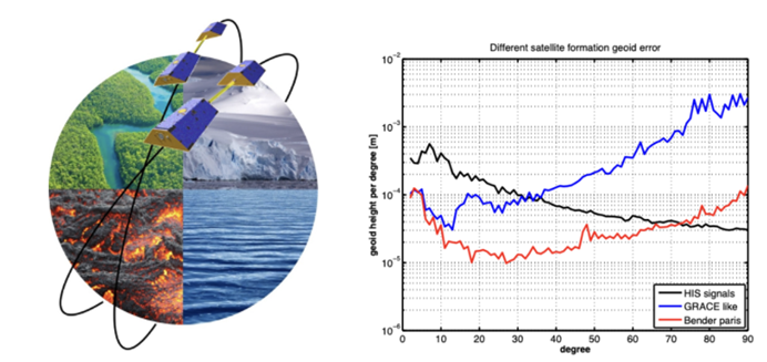
2. Breakthrough in the core technology of satellite gravity field inversion, realize the independent development of high-precision time-varying gravity field products and software; preside over the international cooperation of "China-Europe next-generation gravity satellite", carry out the simulation of next-generation gravity satellite, and promote the construction and implementation of China's gravity satellite program.
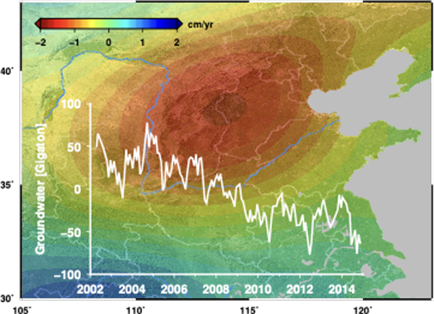
3. In the field of satellite gravity application, we have carried out global and regional land water/groundwater change monitoring based on satellite gravity, and for the first time quantitatively estimated the spatial and temporal distribution and long-term trend of groundwater storage changes in North China, deepening the understanding of deep groundwater changes in North China; the "Gravity Satellite Based Large Scale Drought Remote Sensing Monitoring System" was successfully selected by the Ministry of Water Resources (MWR) in the list of 2021 Mature and Applicable Water Resources Science and Technology Achievements.
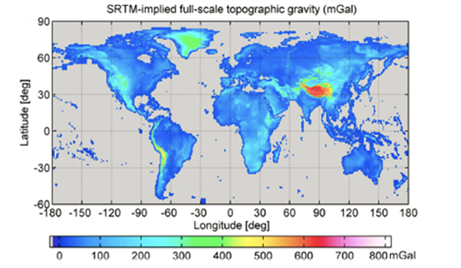
4. We have improved the theory and method of ultra-high-order gravity field modeling, built a high-precision calculation software platform, and released the first global topographic gravity field model, which can be widely used in scientific research and applications such as the determination of regional high-precision geoid, the unification of global elevation datum, and the inversion of the Earth's internal structure.
5. Serving the national strategic needs, he participated in the construction of the "Precision Gravity Measurement" national major science and technology infrastructure, and was responsible for the construction of China's first aviation gravity gradient calibration field and gravity measurement evaluation unit.