
Research News | Geodesy and navigation team of Sun Yat-Sen University makes new progress in the field of high frequency gravity field modeling
Research Background
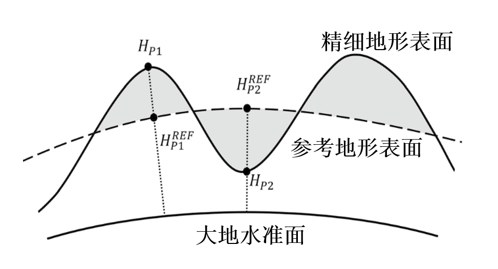
The Earth's gravity field is determined by the material distribution structure of the Earth system and reflects the information of the density distribution inside the Earth. The fine Earth gravity field information is an important basic data for the exploration of major Earth science problems such as deep earth exploration, resource exploration and disaster monitoring and early warning. However, the sparseness of ground gravity data in mountainous areas and other measurement difficulties seriously restricts the construction of static gravity fields with high spatial resolution.
With the development of remote sensing and photogrammetry technology, high-resolution terrain models provide new opportunities for the construction of fine static gravity fields. Based on the residual terrain modeling technique, using terrain filtering to obtain high-frequency information of terrain, and then solving high-frequency gravity field signals by orthoretic theory and methods, it is widely used in the research of ultra-high-order gravity field modeling, regional gravity field refinement, gravity extension and geophysical inversion, which is one of the current frontier research hotspots of fine earth gravity field at home and abroad. In the technique of residual terrain model, when the calculation point is below the smoothing surface, the reconciliation correction is needed. Scientists at home and abroad have conducted extensive research on the reconciliation correction of gravity anomalies, but the reconciliation correction of the geodetic level is neglected, which will introduce large errors in the process of geodetic level refinement.
Research results
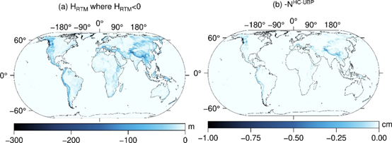
To address the above problems, the geodesy and navigation team of School of Geospatial Engineering and Science of Sun Yat-Sen University has conducted an in-depth study on the correction of geodetic level, and derived the correction formula of geodetic level under the assumption of infinite lattice layer in the framework of classical compression method. In order to overcome the influence of the plane assumption and the error introduced by the mass inconsistency, the geodetic level reconciliation correction formulas are systematically derived under the finite lattice layer assumption, the spherical shell assumption and the finite spherical shell assumption. The article uses the classical EGM2008 gravity field model as the basis, expands the reference elevation model to 2159th order, obtains the high frequency residual terrain model, and then uses the newly derived formulas to calculate the geodetic level reconciliation correction values on a global scale. It is found that the reconciliation correction value is greater than 1 cm when the residual elevation is greater than 295 m. The reconciliation correction value increases with increasing elevation. In the Himalayan region, the value will reach about 10 cm. Therefore, in mountainous areas with large topographic relief, the correction of the geodetic level must be considered. The research results will have important application value in the construction of centimeter level as well as millimeter level geodetic level, elevation measurement of major projects, unification of elevation system of sea islands and reefs, etc. It has important reference significance for the precision determination of Everest elevation.
The results were recently published online in the international journal Surveys in Geophysics (CAS I), entitled "Residual Terrain Modelling: The Harmonic Correction for Geoid Heights The Harmonic Correction for Geoid Heights" (based on residual terrain model). The first author of the paper is Assistant Professor Meng Yang from the School of Surveying and Mapping, Sun Yat-Sen University, and the corresponding authors are Prof. Wei Feng and Prof. Min Zhong from the same school. The co-authors include Dr. Christian Hirt from Technical University of Munich, Germany, Associate Professor Bin Wu from the School of Mathematics, Sun Yat-Sen University, Dr. Xiaole Deng from Southern University of Science and Technology, Prof. Dimitrios Tsoulis from Aristotle University of Thessaloniki, Greece, and Prof. Dennis Hirt from the Chinese Academy of Sciences. Associate Researcher Changqing Wang, Institute of Precision Measurement Science and Technology Innovation, Chinese Academy of Sciences, China.
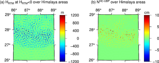
Himalayan region (a) residual elevation and (b) geoid reconciliation correction values
The TGF, a high-frequency gravity field solution software developed by the authors, has incorporated the algorithms of the above research results. The software integrates multiple orthogonal methods and can efficiently and accurately solve the high-frequency gravity field information of the terrain, achieving a calculation rate of ten points per second for 30 m terrain and a resolution accuracy of milli-gamma level. The software has been successfully applied to the development of SRTM2 gravity high-precision gravity field product released by the IAPG Institute of the Technical University of Munich to obtain a global topographic gravity field model with 90 m spatial resolution, which is the highest spatial resolution gravity field model publicly available. In addition, the software system has been applied to gravity field solving in country regions such as Slovakia and Switzerland, achieving an accuracy of 2-4 mega. The software has been shared open source and can provide technical support for gravity field refinement in mountainous areas of China. Open source website: https://www.lrg. tum.de/iapg/forschung/schwerefeld/tgf/.
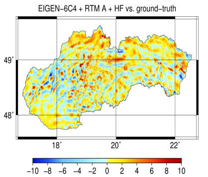
Application examples of the high-frequency gravity field solver TGF in Switzerland and Slovakia
Related published results:
Yang M., Hirt C., Wu B., Deng X.L., Tsoulis D., Feng W.*, Wang C.Q., Zhong M.* (2022) Residual Terrain Modelling: The Harmonic Correction for Geoid Heights. Surveys in Geophysics, https://doi.org/10.1007/s10712-022-09694-4
Yang M., Hirt C., Pail R. (2020) TGF: A New MATLAB-based Software for Terrain Gravity Field Calculation. Remote Sensing, 12(7).
Hirt C., Yang M., Kuhn M., Bucha B., Kurzmann A., Pail R. et al. (2019) SRTM2gravity: an ultra-high resolution global model of gravimetric terrain corrections. Geophysical Research Letters, 46(9).
Bucha B., Hirt C., Yang M., Kuhn M., Rexer M. (2019) Residual terrain modelling (RTM) in terms of the cap-modified spectral technique: RTM from a new perspective. Journal of Geodesy, 93(2089-2108).
