
Science and Technology | World Water Day, China Water Week] "Gravity satellite + InSAR" to help comprehensive management of groundwater overdraft in the North China Plain
"World Water Day
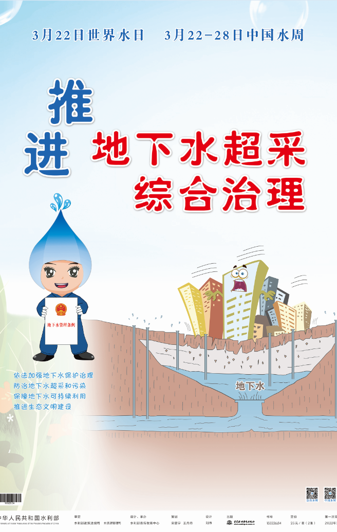
March 22 is the thirtieth "World Water Day", the 35th "China Water Week" publicity activities also opened at the same time. The United Nations determined the theme of this year's "World Water Day" is "cherish groundwater, cherish the hidden resources", China commemorates this year's "World Water Day" " The theme of "China Water Week" is "Promote comprehensive management of groundwater overdraft and recover the ecological environment of rivers and lakes".

Since the 18th Party Congress, General Secretary Xi Jinping has gained profound insight into China's national water situation, and from the strategic height of achieving the sustainable development of the Chinese nation, put forward the water management idea of "water conservation first, spatial balance, systematic management, and two-handed efforts", and established the national "river strategy ", the deployment of major water conservancy projects such as the promotion of high-quality development of the South-to-North Water Transfer Follow-up Project, which provides a powerful ideological weapon and scientific action guide for water management in the new era. Comrade Xi Jinping as the core of the Party Central Committee to promote water disaster prevention and control, water conservation, water ecological protection and restoration, water environment management, a series of fundamental, groundbreaking, long-term work, writing a new chapter of the Chinese people's water governance and peace, the development of water people.

In terms of groundwater protection and management and ecological protection of rivers and lakes, through the implementation of national water conservation actions, strengthening rigid constraints on water resources, the comprehensive establishment of the river and lake long system, and promoting the implementation of a number of major cross-basin and cross-regional water diversion projects, China's water resources utilization has achieved deep-seated changes, water resources allocation patterns have been optimized across the board, and the appearance of rivers and lakes has been historically improved. The comprehensive management of groundwater overdraft in North China has achieved obvious results, with the shallow groundwater level in the Beijing-Tianjin-Hebei governance area rising by 1.89 meters overall by the end of 2021 compared with the same period in 2018, and the deep groundwater level rising by 4.65 meters on average; the Yongding River has been fully connected to water for the first time in 26 years; the ecological water level guarantee rate of Baiyangdian has reached 100%; and many rivers such as Chaobai River and Hutuo River have been fully connected. More and more rivers are restoring "life", more and more watersheds are coming back to life, and more and more rivers and lakes are becoming happy rivers and lakes for the benefit of the people.
How to monitor and prevent groundwater overdraft?
People have been trying to explore.
With the rapid development of geodesy and remote sensing technology, the
people have realized the global and regional
The rapid monitoring of spatial and temporal changes in land water reserves has been achieved.
How do I get groundwater?
In general, the estimation of groundwater storage changes is mainly done through groundwater well monitoring and hydrological model simulation. The construction of monitoring wells is costly and the monitoring range is often very limited; the construction of hydrological models relies on reliable hydrogeological parameters and actual measurement information. The successful launch of gravity satellites has provided an important independent means of observing groundwater changes from space. Interferometric synthetic aperture radar (InSAR) technology can monitor ground subsidence caused by groundwater overdraft in near real-time, and then assess the severity of groundwater overdraft. The two geodetic and remote sensing techniques, satellite gravity and InSAR, reflect the changes of gravity field and surface deformation caused by groundwater overdraft from different perspectives, and provide important references for groundwater resource assessment.
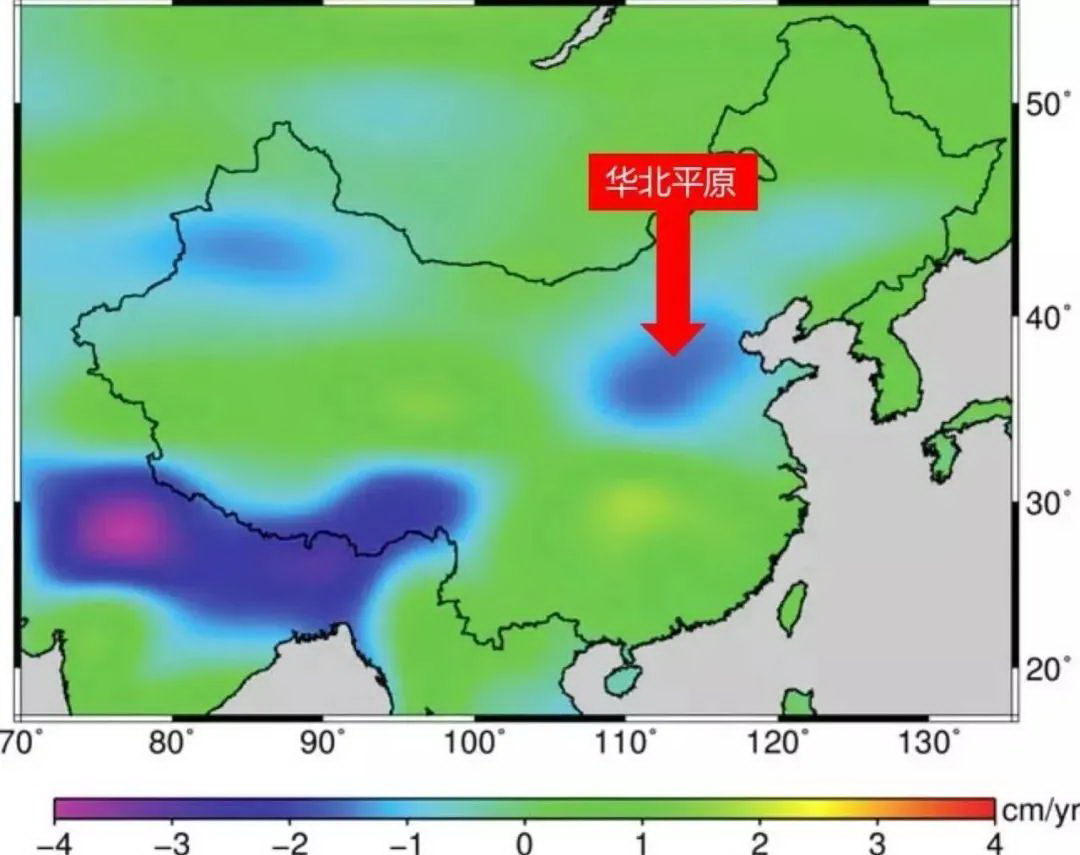
Groundwater overshoot in the North China Plain can be seen on satellites: the GRACE satellite launched by the US and Germany to observe changes in the Earth's gravity field can clearly observe that the gravity and mass of the North China Plain is decreasing due to changes in the water table (as cited in Feng et al. 2013)
Outer space "eye in the sky" reveals groundwater deficits in northern China
In 2002, the GRACE satellite (Gravity Recovery and Climate Experiment), jointly developed by the U.S. and Germany, was launched in a formation of two satellites, orbiting more than 400 km above the ground. When the gravitational field below the satellite changes, the distance between the two satellites will change slightly, from near to far, with an accuracy of microns, equivalent to one percent of the diameter of a hair. Based on the change in distance between the two satellites, researchers can invert the change in the Earth's gravity field. The change in the Earth's gravity field is caused by material migration, including changes in water storage, glacier mass and seawater mass.
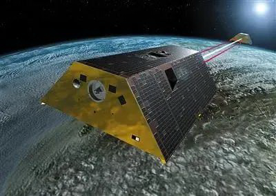
GRACE uses two satellites operating in a group to invert the Earth's gravity field and its variation by using the variation of the inter-satellite distance between the two satellites
In regions with abundant precipitation (e.g., South China), changes in the Earth's gravity field are mainly due to changes in surface water and soil water. And in relatively arid regions, groundwater variation is one of the important factors affecting the variation of the Earth's gravity field. Therefore, in arid and semi-arid regions such as the North China Plain in China, the observation data from gravity satellites can reflect the evolution of groundwater very well. By estimating the total terrestrial water storage changes from the Earth's gravity changes monitored by gravity satellites, researchers can quantitatively monitor the changes of groundwater by combining other measured and modeled information and further deducting the effects of surface water and soil water, etc. Satellite gravity technology is also the only satellite technology that can realize the monitoring of groundwater storage changes on a large scale.
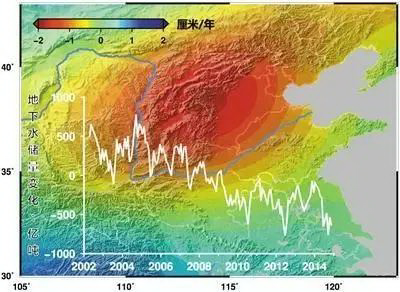
Schematic diagram of groundwater storage changes in North China measured with GRACE satellite
Professor Wei Feng from the School of Geospatial Engineering and Science, Sun Yat-Sen University, has completed a projection of groundwater resource overdraft in the North China Plain using data provided by GRACE satellite. The results of earlier studies show that the groundwater deficit in the North China Plain reached 6-8 billion tons per year from 2002-2014, which indicates that the groundwater resources in the region are in a long-term continuous deficit. In recent years, the groundwater aquifers in northern China have been partially recharged with the south-north water transfer and increased rainfall.
In May 2018, the US-German GRACE Follow-On satellites (GRACE Follow-On) were launched. They replace the two GRACE satellites retired in October 2017 and continue to detect changes in the Earth's gravity field, continuing the monitoring of global and regional changes in water storage, especially groundwater.
The "Tianqin-1" satellite launched in December 2019 successfully obtained global gravity field data, the first time China used a domestic autonomous satellite to measure this data, making China the third country in the world after the United States and Germany to have the ability to independently detect the global gravity field. With the implementation of the next-generation gravity satellite program jointly promoted at home and abroad, people will be able to obtain higher observation accuracy and spatial and temporal resolution of groundwater change information, providing important scientific observation data for groundwater monitoring and protection.
