
Feng Zhao | Research on Earth's rotation, time-varying gravity field and its scientific applications
01
Report Background
In recent decades, space-based Earth observation technologies have developed rapidly. From the perspective of space geodesy, Earth observation technologies mainly include satellite Doppler positioning technology (DORIS), very long baseline interferometry (VLBI), global navigation and positioning system (GNSS), laser ranging (SLR), laser lunar ranging (LLR), satellite altimetry (Altimetry) and gravity satellites (CHAMP, GOCE, GRACE/ GRACE Follow on) and other Earth observation technologies play an increasingly important role in acquiring global surface and deep spatial and temporal information, providing fundamental data for environmental monitoring and Earth system science research.
In the afternoon of May 20, 2022, the 04th "Yat-Sen Intelligent mapping Forum" organized by the School of Geospatial Engineering and Science of Sun Yat-Sen University was successfully held in Room 107, No. 2, Red Building, Zhuhai Campus of Sun Yat-Sen University and Tencent Online Conference. The forum invited researcher Feng Zhao from the Institute of Earth Science, Academia Sinica, Taiwan, to give a presentation. The report was entitled "Earth Rotation, Time-Variable Gravity, and All That". Professor Wei Feng from the Geodesy and Navigation Team of Sun Yat-Sen University hosted the presentation. The presentation started from space geodesy technology and introduced the research work on Earth rotation, Earth gravity field variation and its scientific applications.
02
Introduction
Feng Zhao is a researcher at the Institute of Earth Sciences, Academia Sinica, Taiwan. He received his B.S. degree in physics from National Taiwan University in 1973, and then studied with Freeman Gilbert, a geophysicist, and received his Ph. D. degree from Scripps Institution of Oceanography, University of California, San Diego, U.S.A. He is a NASA/GSFC Honorary Geophysicist, Einstein Chair Professor of Chinese Academy of Sciences, AGU Fellow, IAG Fellow, and member of the Scientific Advisory Board of GFZ, Germany. He was the Director of NASA/GSFC Space Geodesy Laboratory, the Dean of the College of Earth Sciences, National Central University, Taiwan, the Director of the Institute of Earth Sciences, National Central Research Institute, Taiwan, and the President of AOGS Society. He is mainly engaged in research on Earth and planetary physics, global seismology, Earth rotation and geophysical signal analysis. He has published more than 170 papers in Science(4), Nature(2), EPSL, GRL, JGR and other international journals.
03
Introduction to the presentation
Mr. Feng Zhao's presentation is divided into the following parts: the development of space geodesy, the scientific application of Earth rotation and time-varying gravity field.
1. Space geodesy
The three pillars of geodesy (also called geodesy): the shape of the Earth, gravity and Earth's rotation. The technical means used in space geodesy mainly include satellite Doppler positioning technology (DORIS), very long baseline interferometry (VLBI), global navigation and positioning system (GNSS), laser ranging (SLR), laser lunar ranging (LLR), satellite altimetry (Altimetry) and high-low, low-low, etc. Guardian tracking mode gravity satellites (CHAMP, GOCE, GRACE/GRACE Follow-On), etc.
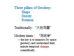
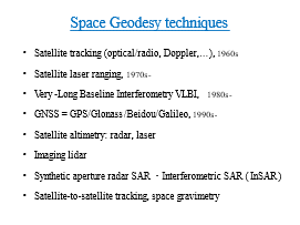
Figure 1 Three pillars of geodesy, spatial geodetic techniques
2. Earth's rotation
The rotation of the Earth refers to the rotation of the Earth around its axis of rotation and the change of the axis of rotation in the direction of space. One revolution of the Earth is 23 hours, 56 minutes, 04.09074 seconds. The average rotation speed of the Earth is relatively stable and slows down slowly over time. Since the Earth's rotation is constantly changing, the Earth's orientation parameters are defined, which are mainly divided into age difference and chapter movement, polar shift, and day length variation. The yearly and lunar variations are due to the slow progression and oscillation of the Earth's rotation axis due to the gravitational effects of the Sun, Moon and other planets. The polar shift is caused by the material movement of the Earth's surface (e.g. ocean tides, ocean currents) and interior (e.g. mantle convection, earthquakes), which causes the position of the Earth's rotation axis in the interior of the Earth to change continuously. The day-length variation is due to the existence of multiple cycles and long-term variations from daily to interannual time scales due to the uneven speed of Earth's rotation.
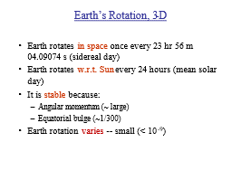
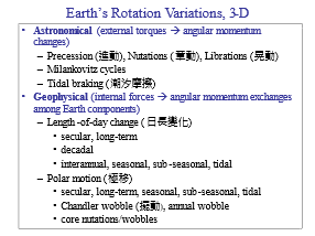
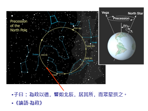
Figure 2 Three pillars of geodesy, spatial geodetic techniques
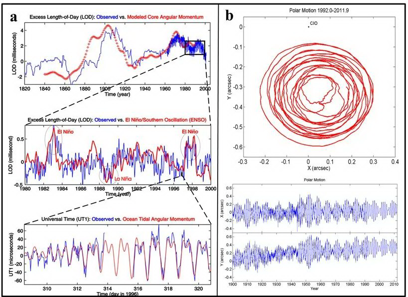
Figure 3 (a) Variation of day length at different time scales with (b) variation of pole shift
3. Changes in the Earth's gravity field
(1) Earth's gravity field
The Earth's gravity field is a physical field that characterizes the spatial distribution of gravity inside, on the surface, or outside the Earth. Similar to the spatial distribution of electric or magnetic fields, the spatial distribution of the Earth's gravity field is irregular. The gravity field distribution depends on the composition and distribution of the material inside the Earth, and is a reflection of the internal density structure of the Earth. In addition, the gravity field changes over time due to celestial gravitational forces such as the Sun and Moon, post-ice rebound, the dynamics of various circles from the surface to the core, and the redistribution of atmospheric, oceanic, glacial, and terrestrial water masses caused by climate change. Determination of the spatial distribution of gravity field and its time-varying characteristics is one of the important ways to explore the distribution, motion, and changing state of materials within the Earth and to understand the dynamics of the Earth system. The accurate measurement of the Earth's gravity field is of great scientific significance for geodesy, geophysics, earthquake mitigation, environmental change monitoring, metrology science, etc.; it is of great strategic importance for ocean exploration, resource exploration and national security, etc. The study of Earth's gravity field is the core problem of geodetic scientific research and one of the most active fields in the development of modern geodesy.
The accuracy of gravity field observed by GRACE satellite and its successor GRACE Follow-On (GRACE-FO) is about 1000 times higher than that of its predecessors, which greatly improves the scope of scientific applications of satellite gravity technology in the fields of oceanography, hydrology, glaciology and geophysics. Figure 4 shows the schematic diagram of the static gravity field of the Earth.
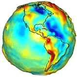
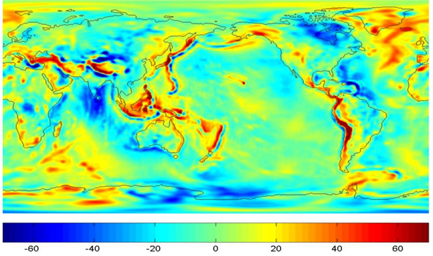
Figure 4 Schematic diagram of the Earth's static gravity field
(2) Time-varying gravity field
The Earth's gravity field reflects the spatial distribution, movement and changes of the Earth's matter. The mass of the Earth system and its distribution are constantly changing with time and space, and the redistribution of mass will lead to changes in the Earth's gravity field at different time scales. The steady-state mass distribution determines the mean Earth gravity field information, and the non-steady-state mass redistribution leads to the time-varying part of the Earth's gravity field.
Figure 5 shows Tapley's GRACE results published in Science in 2004. The figure represents the change in the relative mean gravity field of the Amazon basin in South America in 2003, with red indicating an increase and blue a decrease, indicating that GRACE can observe the mass migration phenomenon in the Amazon basin on a month-by-month basis.
Figure 6 shows the global gravity anomaly trends obtained by GRACE for the last decade, depicting the long-term global mass migration trends, with red indicating a continuous gravity increase and blue indicating a continuous gravity decrease.GRACE provides a new perspective for monitoring mass migration at the Earth's surface.

Fig. 5 Gravity field variation in the Amazon basin for 12 months in 2003 (expressed in geoid form)
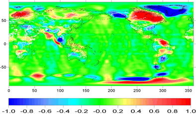
Figure 6 GRACE inversion of global gravity anomaly trends (300 km Fan filter)
04.Conclusion
Mr. Zhao's presentation style was full of personal charm and insightful, which left a deep impression on the audience. After the presentation, the participating teachers and students had an hour-long lively discussion with Mr. Zhao. The presentation has been published in the B-site space of Journal of Remote Sensing [1], and you are welcome to watch the replay.
Figure 7 Online meeting site photos
Copyright Notice
The content and video of the presentation were authorized by Mr. Feng Zhao for publication. This article is only for academic sharing, please cite the source for reproduction. Please contact Fengweiigg to remove or modify some graphics if they are infringing.
