
An on-the-spot report of field gravity and deformation measurement in the Xinfeng River Reservoir area
Wu Hao
School of Surveying and Mapping, Sun Yat-sen University
Xinfeng River Reservoir is located in the west of Heyuan City, Guangdong Province, belongs to the Dongjiang River system, with a catchment area of 5140 square kilometers. The reservoir area is surrounded by low hills and wide water surface. Xinfeng River Reservoir is commonly known as Wanlu Lake in the world, which has both the beauty of West Lake and the momentum of Qiandao Lake. Since the Xinfeng River Reservoir was built in October 1959, there has been frequent seismic activity in the reservoir area. On March 19, 1962, a 6.1 magnitude earthquake struck the Xinfengjiang Reservoir in Heyuan, Guangdong. The earthquake is one of the four reservoir-induced earthquakes above magnitude 6 in the world, and it is also the first reservoir-induced earthquake detected in China, and it is also the largest reservoir-induced earthquake in China. According to the official measurement of the China Earthquake Network, a 4.5 magnitude earthquake occurred in Dongyuan County, Heyuan City, Guangdong on March 8, 2023, with a focal depth of 10 km, the epicenter was located at 23.84 degrees north latitude, 114.52 degrees east longitude. Within 200 kilometers of the epicenter, a total of 10 earthquakes of magnitude 3 or higher have occurred in the past five years. These earthquakes have raised concerns about the geological structure and gravity field characteristics of the region. In order to better understand the reasons behind these phenomena, the geodetic team of the School of Surveying and Mapping of Sun Yat-sen University conducted a survey from July 31 to August 6, 2023. During the days, we set foot in the Xinfeng River reservoir area and carried out a series of field measurement work such as relative gravity, RTK three-dimensional position and soil moisture, as well as field dynamic testing tasks of newly purchased gravity instruments. The measurement plan includes 29 fixed measurement points, including a self-built fixed measurement point for connecting to the distributed optical fiber (DAS) deformation monitoring network of Southern University of Science and Technology. All points were repeatedly measured more than 70 times, covering a total of 1288 kilometers.
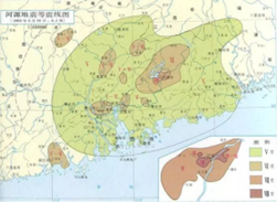
(Isoseismic map of the 1962 Heyuan earthquake).
Professor Zhong Min, PhD student Chen Xiaodong, master student Wu Hao and Wang Haichao of the Geodesy Team of the School of Surveying and Mapping of Sun Yat-sen University participated in this survey journey. We are well aware that behind reservoir-induced earthquakes are complex geological structures and unknown changes in underground materials, stresses, etc., which require us to explore and record them in detail. It was a challenging expedition and a severe test of the professionalism and cooperation of the team members.
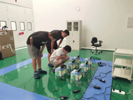
(Preparation of the CG6 instrument before departure).
Every morning, when the first rays of sunlight shine on the surface of the Xinfeng River Reservoir, standing on the shore and watching the rippling water, which has been the site of many earthquakes, we are respectful but also curious. In order to unravel the secrets of this land, we have made sufficient pre-test preparations to ensure that the instruments are accurate and technically skilled.
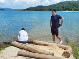
(Team members wash their faces by the reservoir).
However, field work was never easy, and the team did not flinch in the face of the heat and humidity, and the mosquito bites and rugged terrain did not shake our pace. We understand that every measurement point requires accurate data and that every measurement is a tangible contribution.
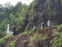
(climbing trails, through the forest).
In every field and forest, we witnessed the rising and setting of the sun and witnessed the beginning and end of the day. In the process, we check the data over and over again to ensure accuracy. Every data point is the result of our relentless pursuit.
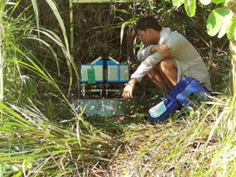
(Measured under the scorching sun).
With tight schedules and heavy tasks, we had to take our own simple dry food at noon and eat in a hurry at the temporary outdoor rest spot. Under the scorching sun, everyone sat together, sharing the food they had brought, eating hurriedly but full of energy.

(Local specialty river shrimp).
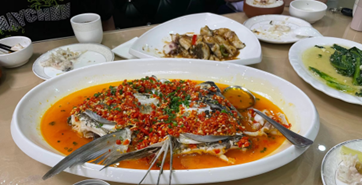
When night falls, the stars in the sky seem to praise our efforts. Team members gather to taste local cuisine. Those fresh river prawns and fish, the essence of this water, exude a tantalizing aroma that entangles our taste buds. The characteristic tofu flower is a unique flavor, smooth and delicate, like a small wish in the world. At the delicious feast, our team is more like a big family, sharing the fruits of labor together and enhancing each other's feelings.
(Last Day Celebration Banquet).
The mission of this measurement was finally completed on a map drawn with a matrix of data. However, this is just the beginning. In subsequent data analysis and research, we will continue to dig into the stories behind the data and take a bigger step to unravel the mysteries of the earth.
The Xinfeng River field measurement trip is not only a collection of data, but also a reverence for nature and the pursuit of knowledge. We will continue to maintain enthusiasm and perseverance to interpret the value and significance of surveying and mapping with practical actions. In this land where earthquakes were frequent, we recorded valuable data with measuring instruments, and also contributed to seismic scientific research. This expedition will forever leave its mark on our hearts. Finally, I would like to thank experts such as Liao Guijin, Tang Guoying, Liu Jiping and other experts from the gravity team of Guangdong Earthquake Bureau for their strong support and guidance on the field survey mission in the Xinfeng River and Pearl River Delta regions.
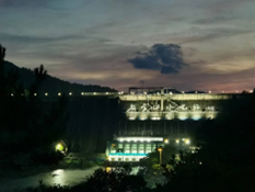
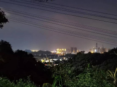
(Xinfeng River Reservoir Dam, Mountain City Night View)
